Hurricane Dorian has absolutely battered the Northern Bahamas over Labor Day weekend, bringing fierce Category-5 winds, devastating storm surge, and up to 30 inches of rainfall. The storm's westward movement began to stall out late on Saturday, as a ridge of high pressure over the Atlantic began to break down. In the absence of any steering currents, Dorian pounded the tiny islands ceaselessly on Sunday and Monday.
Now this upper-atmosphere weather pattern is beginning to change, and, albeit slowly, Dorian is beginning to turn northwest away from The Bahamas and toward the Continental United States. At 11am ET Tuesday, it was moving 2mph to the northwest, according to the National Hurricane Center.
It has been unclear for days how close Dorian would get to Florida and the rest of the United States, but now it seems likely that a trough of low pressure moving across the upper Midwest and northeastern United States will be strong enough, and fast enough, to keep Dorian away from the Sunshine State. We still have downstream concerns about the Carolinas, however.
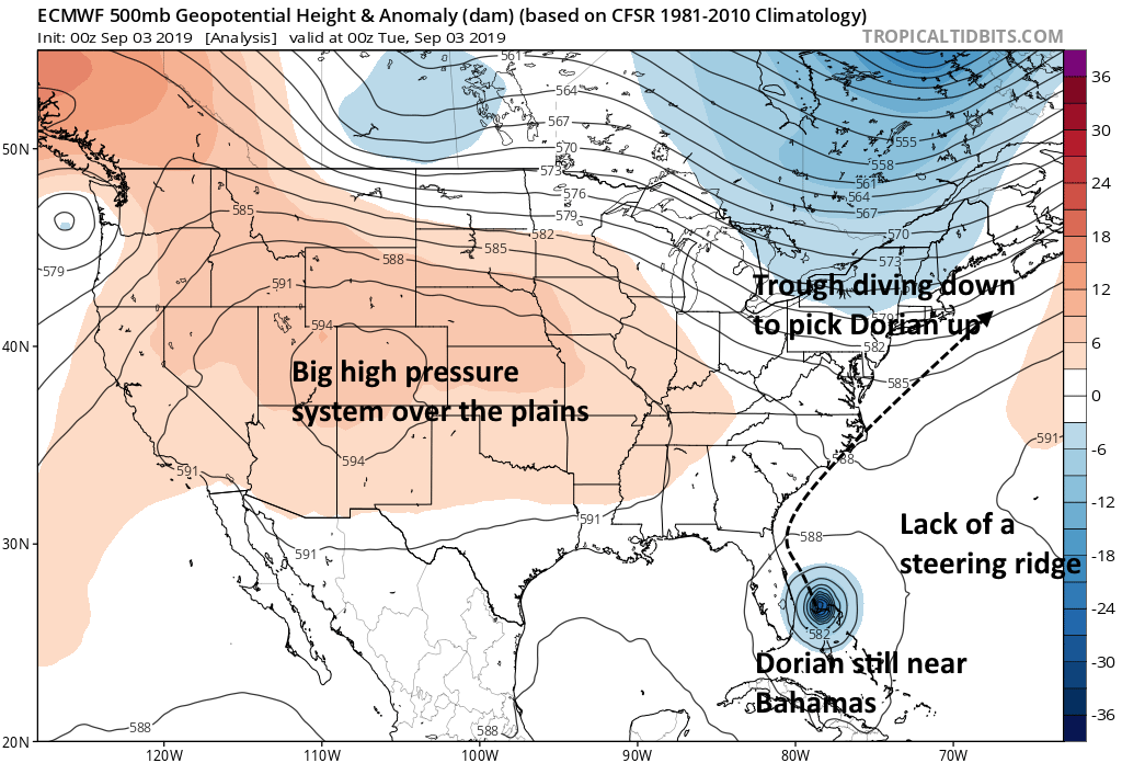
Attached to this post, the plot of atmospheric heights at about three miles above sea level—it is the European model's depiction of conditions late Monday night—shows the air pattern nicely that will pull Dorian away from The Bahamas on Tuesday. The trough has created enough of a break in the upper air pattern to nudge Dorian northward, slowly at first, but the storm will accelerate later this week as it gets entrained into the southwestern flow of the trough and pulled rapidly to the northeast. Less than a week from now, its remnants will likely be just south of Greenland.
Good for Florida
In terms of impacts, this is good news for Florida, as the evolution of the trough should keep Dorian's worst winds, waves, and rainfall offshore. However, the new forecast track from the National Hurricane Center brings Dorian very close to the South and North Carolina coasts on Thursday and Friday. A landfall in one or both states remains possible.
How strong Dorian will be at the time is an open question. As it stalled out over The Bahamas during the holiday weekend, Dorian upwelled cooler water from the ocean depths, and this has helped to weaken the storm from a peak of 185mph maximum sustained winds down to 110mph. As it has remained stationary, the storm's central eye has also gradually expanded as it has lost some of its previous tight circulation.
The National Hurricane Center anticipates that Dorian will more or less maintain this intensity as a Category 2 hurricane for the next two days as it moves northward—about the time it will come closest to South Carolina. After this point, it should encounter wind shear and significantly cooler ocean temperatures that will further weaken the storm.
As Dorian begins to pull away from the United States this week, other threats will emerge in the tropics as more vigorous waves move off of Africa into the eastern Atlantic Ocean. These will bear watching, as we are now in the midst of the climatological peak of hurricane season, and one or more of those should track toward the Caribbean Sea. However, perhaps our most immediate attention should go toward helping The Bahamas, which has been ravaged by Dorian.