SCIENCE
Hurricane Dorian is going to come very, very close to Florida
Latest forecast models are coming into better agreement.
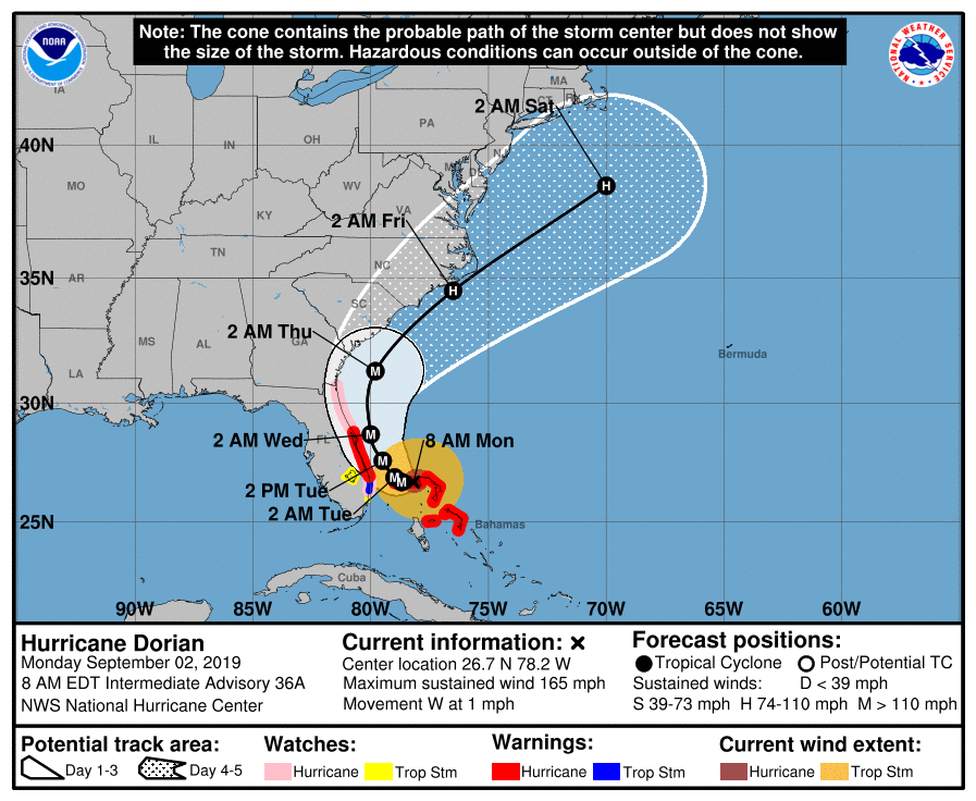
During the overnight hours, Hurricane Dorian has pounded the northern Bahamas with devastating winds, storm surge levels of 20 feet above normal, and very heavy rainfall. Dorian has tied the Labor Day Hurricane of 1935 with the highest landfalling wind speeds in the Atlantic basin, hitting Great Abaco Island with 185-mph winds.
The storm has weakened slightly this morning, as its eye has expanded, and its organization lessened a little bit. As of 8am ET, the National Hurricane Center estimated winds at165 mph.
Another significant problem is that high pressure to the north of Dorian has weakened during the last 24 hours, causing the storm's steering currents to collapse. This has led Dorian to essentially halt over Grand Bahama Island on Monday morning, prolonging the Category 5 hurricane misery over the northern Bahamas. The tweet from the National Hurricane Center's Eric Blake demonstrates this painful stall over the Bahamas.
Horrible situation for Grand Bahama Island this morning as #Dorian just sits there as a category 5 hurricane. Reminds me of Wilma near Cozumel where it stalled and caused tremendous damage. Stay safe! 🇧🇸 pic.twitter.com/aa6h56R59O — Eric Blake 🌀 (@EricBlake12) September 2, 2019Eventually, a trough moving southeastward through the Midwestern United States will get close enough to Dorian such that it picks up the storm, and pulls it northward, and then toward the northeast. However, it increasingly looks like this turn will come very close to the Florida coast.